|
Phyllis’ Journal |
|
Phyllis’ Journal 2006-A This is a chronicle of 4 Morgans: Larry, Phyllis, This page covers our second full year on the road (Jan— July) Areas visited include : Arizona, Southern California, Southern Nevada, Southwest Utah |
|
Page Last Updated: 8/10/2008 |
|
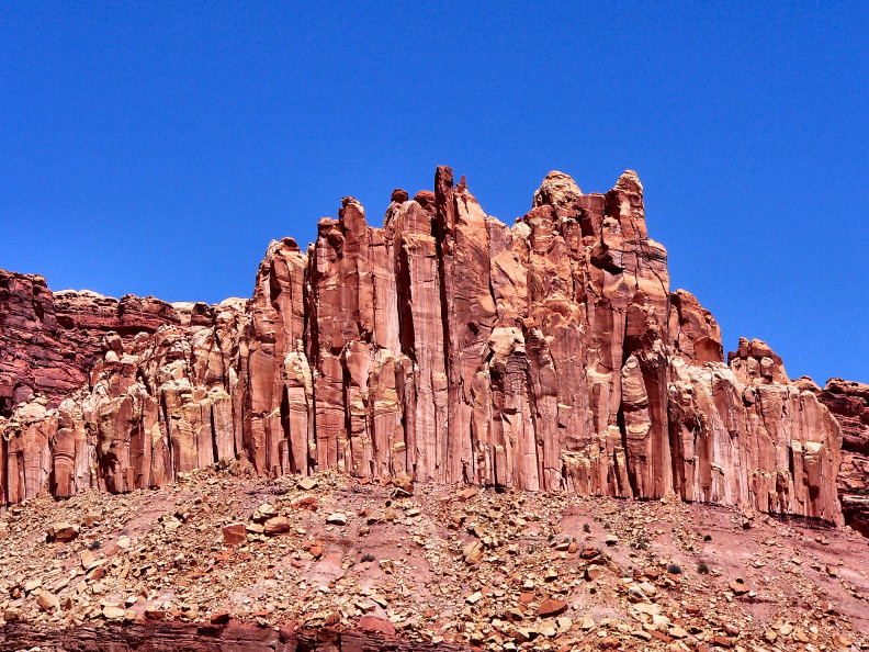
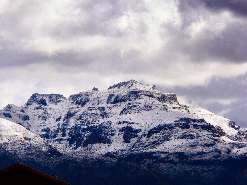
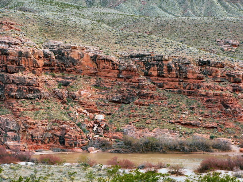
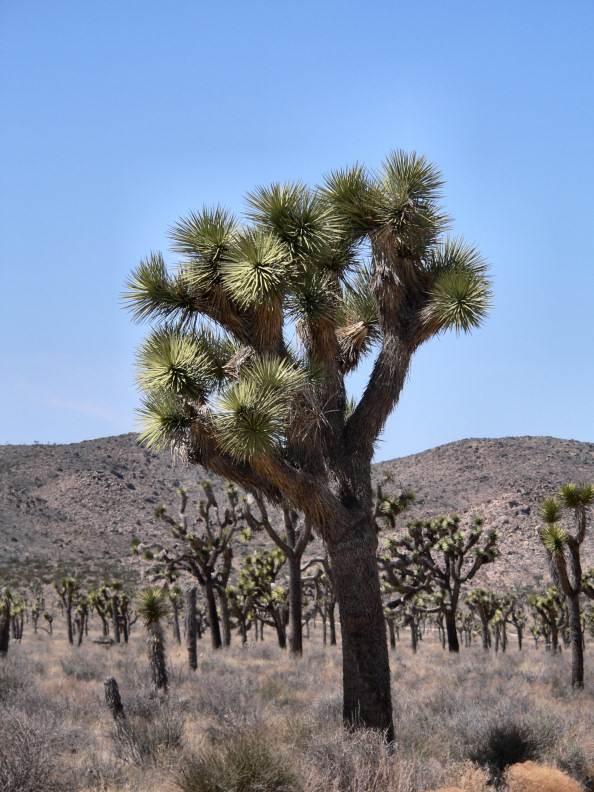
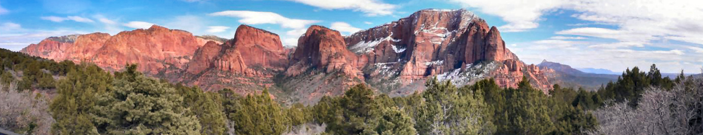
Today is June 17. I will try to get caught up with this journal. I tried several months ago but my mouse went crazy and I haven't gotten back to it. I'm sorry to those of you who are following our dream. We left Apache Junction on March 13. It was a long winter for us. The air quality was so bad that Larry and I suffered from constant headaches from sinus infections. We only had one real rain from October to the time we left. We also had snow on the dominant mountain. That was the first snow in 25 years. It was beautiful. On leaving Arizona we traveled to California. We were checking out jobs for winter of 2006-2007. We took the dogs to the Pacific Ocean and play on the beach. Also we restocked at Sam's Club and headed east again. While in the area, we contacted Carolyn and Lucy, whom we met in Texas (winter of 2005-06). We boondocked with them for 2 days. It was great being with friends. Larry and I continued east to the Palm Strings, CA area. It is pretty but way to expensive, plus Larry and I aren't golfers. We continued on to a town called Twenty-nine Palms. We again were job shopping for winter '06,'07. While there we went to Joshua Tree National Park. We were delighted with this place. We want to camp here sometime. The Joshua trees look like a combination of Saguaro Cacti and scotch pine trees. There was an observation area that overlooked the mountains around Palm Springs and that city plus we could see the San Andreas Fault. That was very interesting and we were able to photograph it. We continued east to check out the Bullhead City, AZ and Laughlin, NV area. We do not gamble and were not terribly comfortable in these areas, so we were on our way. This life-style is great. Where we were searching for winter jobs and were not impressed with the city areas we did not have to stay we could continue on. Larry and I are amazed at God's handiwork and are not impressed with most cities (there are few exceptions). Now after the above paragraph, you are going to ask why we were going to Las Vegas. The answer is that this is the last Sam's Club available until we leave our current location. We shopped Sam's and hightailed it out of there. We picked-up I-15 and it came down to the Virgin River (this flows through Zion National Park) valley in AZ. We camped for the night at Cedar Pockets. This was a delightful find. The Virgin River has cut a beautiful valley. We continued the next morning. It is about the third week of March. We needed to be in St. George, UT to have our transmission looked at. While in Apache Junction, we had to replace our transmission with a much heavier duty one (Cottman-Hill Killer transmission). While traveling, Larry noticed the truck was not shifting as smoothly as it should. Upon taking it to the Cottman place in St. George they found an electronic device had gone out. Fortunately the transmission was under warranty. Also, they were able to put more cooling ability in for the transmission. While in St. George, we visited Zion--both sections. The main part is beautiful; but I think Larry and I both enjoyed the Kobel Canyon part the best. The overlook at the mountains and valley were magnificent. It amazes me how God can take a simple idea like a mountain and give it so many shapes, textures, trees, waterfalls, animals, etc. These mountains had a high mountain pasture on the west and descended to a jagged inverted V-shape in the middle, and I'll have to review the photos to remember the rest. |
|
Arizona — San Diego — Nevada — Utah |

|
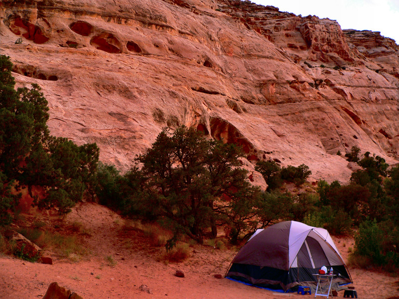
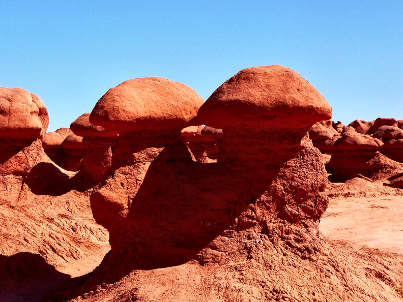
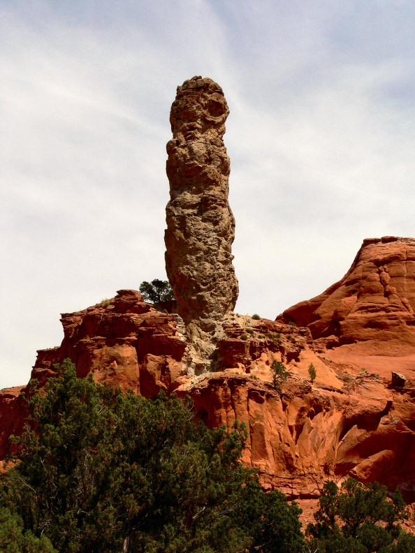
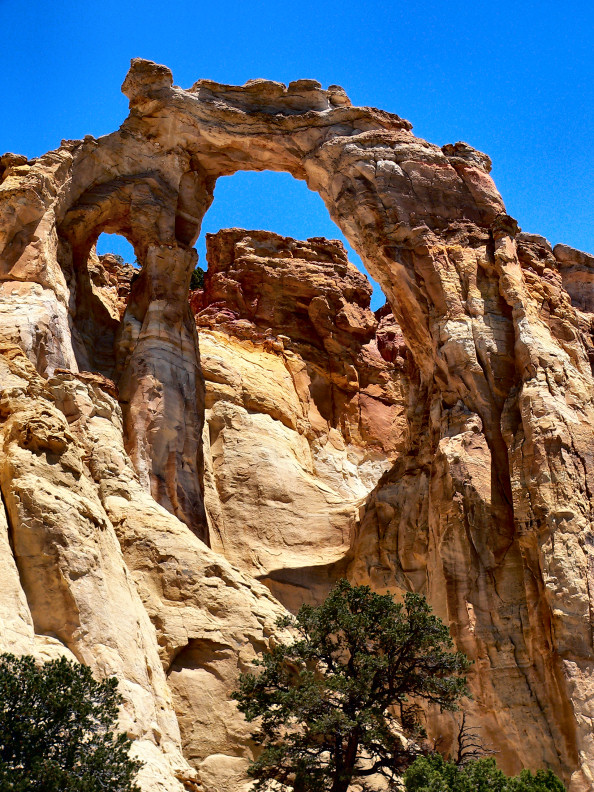
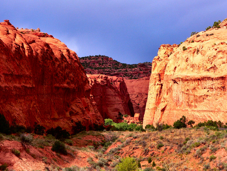
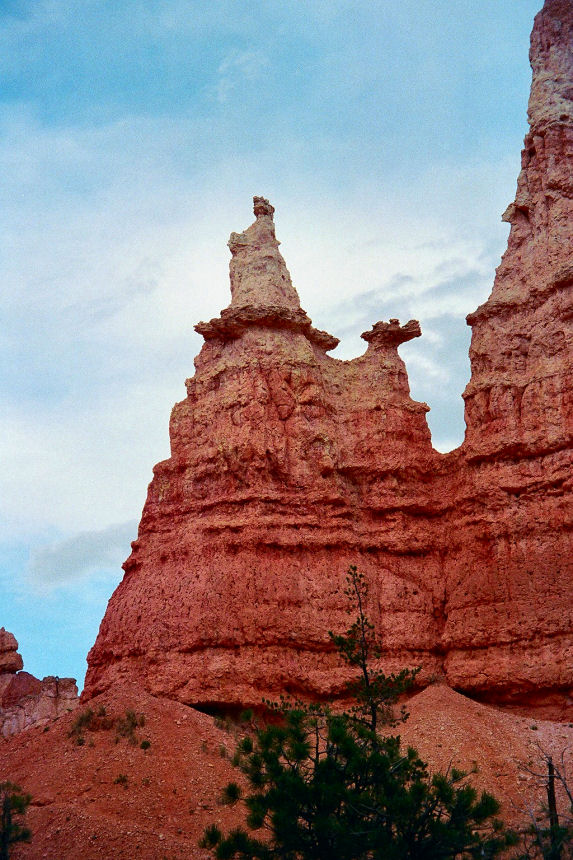
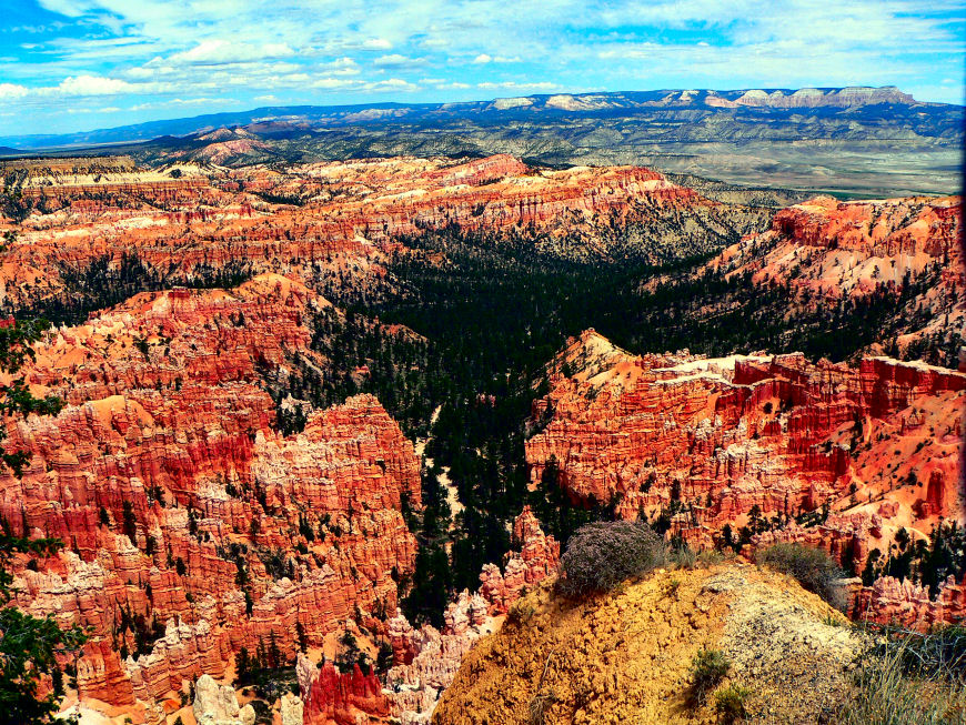
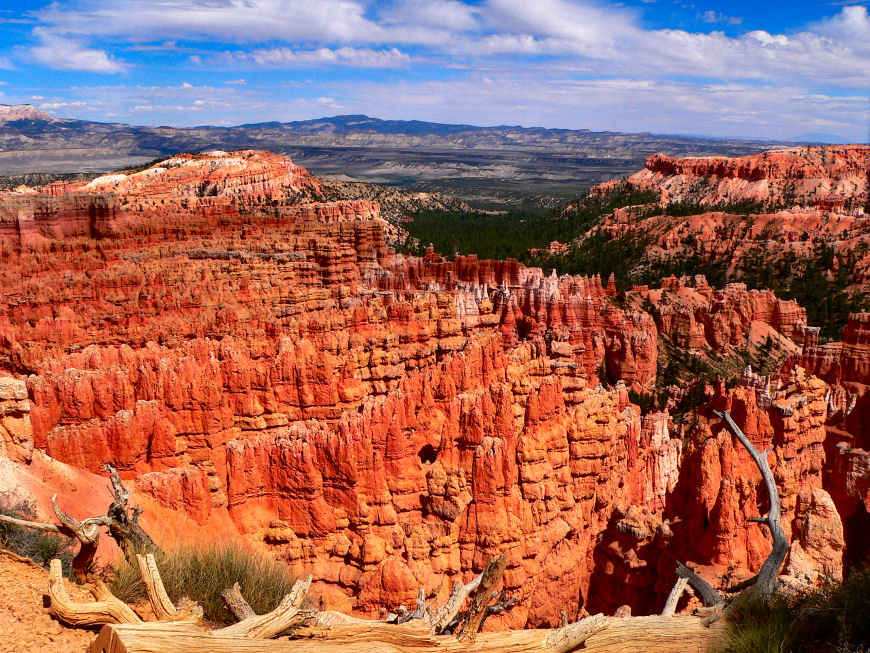
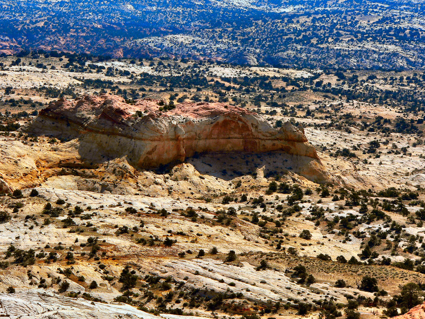
It was past-time to head out. We were due at Bryce Canyon April 1. We had to wait for the transmission repair and the weather at Bryce. It was snowing there. Finally on April 6 we were on our way. We decided to go across the AZ strip on over to Kanab, UT, continuing north on 89. Again, just like last Sept., we are amazed at Red Canyon (Larry calls this the appetizer to Bryce Canyon). Upon arriving at Ruby's Inn, we proceeded to the campground office. Shaunna, the manager, was not in. Fortunately we knew where to park. Finding our spot we set up for a six and a half months stay. We are working about 32 hours a week. This has limited our expeditions; but we are trying to make the best of it. There are three national parks in a day's drive. Bryce, Zion, and Capitol Reef. We took off on Utah 12--one of our Nation's amazing drives. It is an experience in geology with fantastic views, steep mountain roads, and turn-offs to almost unspeakable delights. Our first such drive on Utah Highway 12 took us to Capitol Reef. It has canyons, that have gigantic walls, which some people think the tops look-like the Nation's Capitol Building. Harpo and Roscoe loved the picnic area. It had humongous cottonwood trees. They must have been hundreds of years old. We decided that buying a tent, sleeping bags, air mattress, etc. would add more range to our adventures. The first time out we took off on Utah 12 again looking for a camping spot. First we looked in Tropic at the base of Bryce--found nothing. We continued to Cannonville (next town east). Here we stopped at the BLM office to get some suggestions. We continued on. We tried Calf Creek Falls--they were full. Next we turned onto the Burr Trail--what a wow road. We headed for Duck Creek Campground--full. It is starting to get late in the day. We turned back west and looked at side roads for a possible camping place. None panned out. We headed home. The next morning we went to Red Canyon and set up for the night. Our air mattress went flat--Larry re-inflated it. It went flat again. Night passed. We returned the air mattress to Wal-Mart and ordered one on the web. Our next tent camping excursion again took us across Utah 12. We were headed toward Goblin Valley. This took us through Capitol Reef. We first became acquainted with Goblin Valley in the movie Galaxy Quest. The maze of small hoodoo formations is unearthly--like we had been transported to Mars. The campground was full so we looked for a spot on BLM land. We finally found a spot after rejecting several. Our campsite looked as if a million years before it had been part of an active body of water. The rock walls were pitted by what looked like whirlpools and rushing water. This area is desert, so we were on sand with some plant life. During the night, I had to get up. I did not zip the tent completely and after getting back into the sleeping bag I thought I saw a white flash. We heard scampering. Harpo and Roscoe got very excited. I had let a mouse in with us. Finally it must have gotten out. We decided not to stay a second night. A third tenting outing, as yet, has not been planned. Before I go on with adventures, let me explain our job which allows us to spend so much time in an area. Larry and I work in the campground office. We take reservations, check people in, help people explore the area by giving information, listen to complaints and try to make their experience better, sell product from the campground store, and check the campground. Larry does a lot of computer related work. Roscoe and Harpo really like it here. Dixie National Forest juts up to Ruby's Campground. The dogs can run off-leash here. They love this. On UT 12 is a town called Cannonville (about 15 miles from Bryce). There is a side road that goes to a state park. The Park is called Kodachrome Basin (named after the Kodak film). The formations here look as if a geyser was frozen in time. They a filled with conglomerate rock and I don't know what else. They stick up high in the air (several hundred feet). At the turn for Kodachrome is a “Y” in the road. The left fork is Kodachrome the right fork is a gravel road. This road is called Cottonwood Road. It goes all the way into AZ. About 17 miles down this road is a wonderful double arch formation called Grosvner's Arch. The right side opening is huge (several hundred feet high; at least 30 feet wide. The left side is much, much smaller. When we want to go to a Wal-Mart we have two choices: Cedar City is the closest at 73 miles; the second choice is Richfield at about 90 miles. When we go to Cedar City, we travel an amazing mountain road--UT 14. It goes up to about 10,000 ft. There is a field of lava flow there that was caused by cracks in the earth. It rises to 1000 ft. or more--a mountain of dried lava. A little further down Highway 14 is an overlook of Zion National Park--Wow! Our other choice for Wal-Mart takes us north on US 89. The drive is pleasant and the mountains are beautiful. On Such mountain I mentioned last year on our first time in the area. This mountain is Big Rock Candy Mtn. It has a sulfur spring in it that has given it some of its color--like lemonade. We really like the roads less traveled. One such road is the Burr Trail. You guessed it--it's off of UT 12. This road goes to Long Canyon. We went down a very steep hill into huge walls of red-red rock. Here we saw an arch forming. We couldn't understand why this also wasn't a national park--much better than Zion. The road continued on to the top of a mountain, where we had to descend down a series of very steep, tight switch-backs--at least 1500 ft. We took the most amazing hike into Bryce. We went to Sunrise Point and down the Queen's Garden Trail. It is a totally different experience looking at the hoodoos on top and then going down amongst them and looking up. This trail took us through the Queen's Garden, to and in her castle, through three doors, then at the bottom (320 feet latter) we reached Queen Victoria--a hoodoo that looks like a queen high on a pedestal. Today is August 18. We took an absolutely wonderful hike. We took the shuttle into Bryce Canyon to Bryce Point. We started down the rim trail to Inspiration Point. Oh my! Wow! We walked about a third of the way around Bryce Point. We got different views of windows we saw from above, grottos carved into the walls by water, ice and wind. There is a feature at Bryce Point that looks like a gigantic alligator (actually it looks like very smooth concrete toweled on top of the hoodoos). As we hiked down and then back up the magnitude of the red rock formations hit me. There are canyons and crevices in between castle-like walls. As we walked 10-20 feet then turn back the scene changed, you could see more hoodoos, more canyons. We had to walk across several back-bones. There was a long way down on both sides. We were walking on loose rock part of the time, over roots and imbedded stones. Heights didn't used to bother me--they do now. To get to Inspiration Point, you have one more sizable hill to climb. Here the hoodoos are like a huge army of soldiers that have been turned into red-rock soldiers, one on top of another. You can see from this high vantage point back into Bryce Point and forward into Sunset Point. We came down the point and continued on toward Sunset Point. Wow! It is almost impossible to describe the view to you. We were able to look back into both amphitheaters--Bryce and Inspiration. It must be a very special place to God. He took exceptional care in the carving these awe inspiring views. On reaching Sunset Point we were tired and hunger. We took the shuttle to Bryce Canyon Lodge to check on the restaurant (we'll eat here when we drive in) and we stopped at the gift shop and found some treasures. We took the shuttle back to Ruby's, walked the dogs, and went and had a delicious meal and a bottle of wine--what an amazing day. |
|
TravelingMorgans.com |
|
Our Home is Where We Park It |

|
NOTE: Click any picture to get a larger version. |